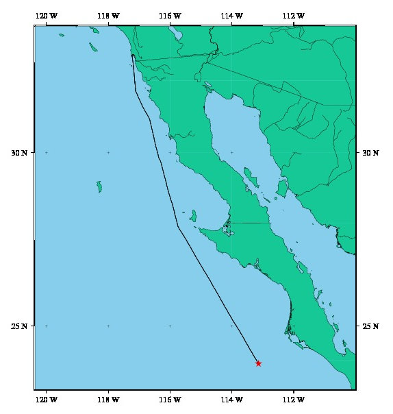
Tuesday, October 25, 2011

The transit goes on...


Date: 2011/10/26
Time: 00:33:36 GMT
Latitude: 7 ° 41.0781 N
Longitude: 87 ° 41.4102 W


We left station early Sunday afternoon, and began our long transit toward Panama. The seas have been smooth and we've been making great time. You can tell that we're getting closer to land - we saw a fishing boat today, and encountered a couple of large pods of dolphins. We're spending the time finishing up data processing, beginning interpretation, and watching loads and loads of movies.

Saturday, October 22, 2011

Homeward bound


Date: 2011/10/22
Time: 21:17:36 GMT
Latitude: 9 ° 59.7093 N
Longitude: 104 ° 5.2029 W


With little fanfare but much silent rejoicing, we point our sails homeward. There's still a great deal of work to be done by all of us, and yet a certain sense of finality has set in. I'm absolutely certain I will regret saying that even as I write it when I'm staring at an unprecedented weight of files to ping edit, but there it is. Kevin is currently working with the MAPRs, and he has assured us that data has indeed been collected. Part of our job for this upcoming transit will also be analyzing and visualizing this data in addition to the aforementioned ping editing. On a side note, the EPR area decided to give us a bit of irony right at the end of our time there by being uncharacteristically characteristic. After nearly two weeks of unruliness, clouds, rain, and waves, the water was like glass this morning, and the clouds were modestly distributed. Julie and I even saw a school of fish swimming along beside the boat for a while this morning. I have been assured that this is the image I should carry away of EPR, not the tempestuous sea that plagued us for a majority of the cruise. That's okay though; the days of storms are over, and seasickness is soon forgotten. Again, I am absolutely certain that I will regret saying that when, possibly very soon, the ship is crashing through waves on its way back to Panama while I lie in bed incapable of physical activity of any kind.

Thursday, October 20, 2011

Making our way north

Date: 2011/10/20
Time: 19:09:08 GMT
Latitude: 9 ° 37.86864 N
Longitude: 104 ° 15.45162 W


During our current dive, we're maneuvering Jason on a very long transect along the crest of the East Pacific Rise. We began in the south at around 9° 4'N and are slowly making our way north. We expect to continue this transect, with a few small detours, until the end of our time on site. Our hope is to make it as far north as possible toward 10°N. The main objectives of this dive are to (1) recover instruments deployed on the seafloor, (2) map the shape of ridge crest at very high resolution, and (3) collect water column data along the ridge crest that may reveal the signal of hydrothermal activity. We are also collecting a few samples here and there when we come across interesting things on the seafloor.

The transits between stations are done with Jason well off the seafloor in an effort to maximize sonar data coverage, which means there's not too much to see besides the profile of sonar data as we encounter variable terrain. When we break off our transect to look for the instruments, however, we get to see the seafloor and make visual observations and collect photos and video.

Tuesday, October 18, 2011

Monday, October 17, 2011

Basalt and styrofoam


Date: 2011/10/18
Time: 03:59:08 GMT
Latitude: 9 ° 38.45778 N
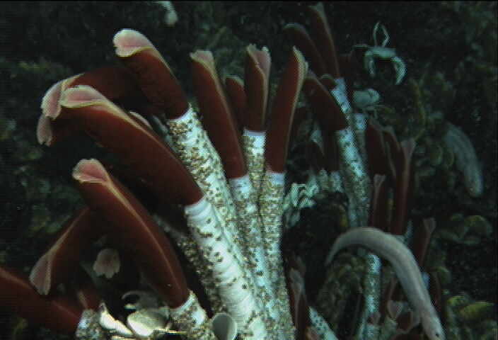
Longitude: 104 ° 15.45264 W

In addition to the selfless liberation of tube worms from the seafloor, the group from Vienna managed to liberate several rocks for us. These mid-ocean ridge basalts were on a long 20 million year trip ending in their subduction beneath Central America and eventual incorporation back into the mantle. Instead, they've won an all expenses paid trip to Panama followed by their eventual deposition in our New York apartments. If you take a look at the image, you can see the glassy chilled margin on the outside of this basalt, a testament to its extrusion in water and a very effective way to get splinters of glass in your fingertips.

In addition, all of us spent time making shrunken cups for ourselves and our loved ones. We sent them down on the elevator that carried the tube worms to the surface. The concept behind these cups is simple. As the cups are transported to the bottom of the seafloor, the pressure of the water increases. At 2500 meters (8000 feet), a cup is feeling a pressure of about 250 bars, or, more impressively, 3640 pounds per square inch. The Styrofoam isn't really made for these kinds of conditions and gets compressed, the end consequence of which is that the cup is turned into a miniature of its former self. Suffice it to say, they're really popular as gifts. While those of us new to the ritual naturally wanted to take part, we were surprised by the avid response from the PIs. This may be the first step in instituting weekly LDEO Marine Geology & Geophysics coloring time.

Lately, our group has been working on processing data from the multibeam connected to Jason. It looks like some really interesting data so far, and I'm sure you'll hear a lot more about it.

Sunday, October 16, 2011

The dive continues...


Date: 2011/10/16
Time: 15:33:08 GMT
Latitude: 9 ° 51.04344 N
Longitude: 104 ° 14.09754 W

After a full 24 hours in the water, the dive continues. We successfully sampled some tubeworms yesterday afternoon and sent them to the surface - one is currently being kept alive in a pressurized aquarium! We are now continuing to map and visit benchmarks. By this evening, we hope to begin our southward traverse along the axis of the East Pacific Rise to recover instruments and continue mapping....

Saturday, October 15, 2011

Back on the bottom!


Date: 2011/10/15
Time: 16:20:08 GMT
Latitude: 9 ° 50.90946 N
Longitude: 104 ° 17.50134 W


We just started our second dive! The first dive gave us a chance to collect some data at a few sites, and to get the team up to speed with our objective and sampling protocols. Everyone is eagerly awaiting more data!

During this dive we hope to map a significant area of seafloor as we visit each of the benchmarks for additional pressure measurements. During the first dive, we tested out different sonar surveying parameters and figured out exactly how we want to acquire the rest of the data. One of the main objectives of our mapping effort is to better understand the geologic features on the seafloor, and to determine how the seafloor was changed by the volcanic eruption that took place here a few years ago.

We will also be sampling some tube worms at one of the hydrothermal vents in the area. In a few hours, the tubeworms, and several instruments that will be recovered during the dive, will be sent up to the ship using an "elevator", while Jason continues to work on the seafloor.

The weather forecast has improved and the outlook is good for the remainder of the trip!

Thursday, October 13, 2011

Jason and the Benchmarks


Date: 2011/10/13
Time: 19:03:09 GMT
Latitude: 9 ° 50.5623 N
Longitude: 104 ° 16.371 W


It's been an eventful night, most definitely. Vicki, Julie, and I were up before 3 a.m. and ready for our shift in the control van. Julie pulled the job of event logger, while I was given the amazing opportunity to be the 'video logger' (DVD changer). Vicki, of course, was the science lead for the night, which won her a special chair with hydraulic raising and lowering action, a feature that Julie and I both coveted greatly. We were greeted when we walked in the door by a very upset dumbo octopus on the main screen. After inspecting Jason briefly, he backed away and expanded outward, flashing some bioluminescence in our direction as if to say "This is my space!"

Jason's main task for the night was collecting transponders from some benchmarks across axis and making a precise measurement of the pressure at each benchmark using a mobile pressure recorder (MPR). These pressure measurements are used ultimately to determine whether the benchmarks have moved at all, and therefore, whether the ridge itself is deforming. In addition, between these benchmarks, Jason is moving up to 50m above the ocean floor and collecting multibeam data that can be used to construct an extremely precise (<1 meter resolution) map of the seafloor. We have traveled to about half of the benchmarks at this point, and then it's on to more fun and excitement.

Wednesday, October 12, 2011

Jason IS IN!!!!


With a brief opening in the weather that never stops, the Jason group was able to safely put Jason in the water!  Our watchstanding will now be inside the control van... more pictures to come.

Meet Our MAPRs

Thanks to the generosity of Ed Baker and Sharon Walker at NOAA/ Pacific Marine Environmental Laboratory we have six Miniature Autonomous Plume Recorders (MAPRs). These cute devices record temperature, pressure, optical backscatter and oxidation-reduction potential, all together those measurements help identify the signal of an active hydrothermal vent. We have one MAPR attached to JASON, one on Medea and the remaining four attached to the cable at a 40m spacing.


Tow-Yo Yo Yo Yo

On our way to breaking the world record for longest Tow-Yo line ever!!!! Maybe? On downcast 120.

Weather is still not cooperating, it is very likely that Irwin will turn and follow us all the way down the axis.

Tuesday, October 11, 2011

Tow-Yo own CTD


Watch schedules have begun. Everyone has their 6hr watch with Vicki, John and myself lucky enough to sit 3am-9am. Since the weather refuses to behave long enough to put Jason in the water we are plume hunting with Tow-Yo CTD lines. CTD stands for Conductivity, Temperature and Depth, the actual CTD is mounted to the bottom of the rosette which currently has eight Niskin bottles for water collection. Traditional CTD casts are vertical and a single instance of up and down. Tow-Yo casts are run as lines where we yo-yo the CTD over a distance, ranging between 20m-300m off the seafloor, with the goal of finding hydrothermal vent plume signals. Last night the CTD was put in the water and a short off axis segment was towed. The CTD was then recovered and relaunched at the beginning of our shift for the longer on axis line and we may have the CTD in the water for the next day or so, until the waters have calmed down enough for Jason to go in. Until then it's winch minding and event logging for all us watch standers.

Monday, October 10, 2011

Haunted by Hurricane Jova

Jova is now a Category 3 Hurricane, and is forecast to become Category 4 before it makes landfall in Mexico later this week. Although Jova is considerably north of us, we are getting nasty swell from this monster storm. This means it's not safe to launch the ROV, so we're delayed until the weather improves. Sadly, it will get worse before it gets better. In the meantime, we're going to figure out the best way to utilize our time here -- probably more ship-based multibeam mapping and some CTD Tow-Yos.

Sunday, October 9, 2011

On site, time for action


Date: 2011/10/10
Time: 01:56:40 GMT
Latitude: 9.85244
Longitude: 104.208602

Assuming the weather starts to clear up some, we'll be deploying Jason after breakfast tomorrow, which means at least one very important thing: we won't have to get up at 3 a.m. until Tuesday. Unfortunately, the weather may mean we won't have to get up at 3 a.m. for a while, so we're watching closely and hoping that things clear up. There are a few backup plans including filling in some gaps in the multibeam bathymetry coverage and running a towed CTD (Conductivity, Temperature, Depth) survey in the meantime. We're not talking about these though, as that would be considered giving up. One other major benefit of being here is that the massive heave associated with cruising along has effectively been eliminated, which is really helping our seasickness.

Are we there yet?


Date: 2011/10/09
Time: 16:50:08 GMT
Latitude: 11 ° 23.75616 N
Longitude: 105 ° 15.45264 W

As we approach EPR, the seas have set down a bit, which is good. Apparently though, we're just between storms. According to the weather sites I've looked at today the 3 (yes 3) tropical depressions/storms/hurricanes out here in the East Pacific are not an imminent threat, but word has it there's yet another one brewing. That one is said to be right on top of our work area...

We are due to arrive on site this evening. First task will be calibrating the ROV nav system overnight. Then hopefully, and weather permitting, we'll be in the water on our first dive tomorrow morning.

In the meantime, we've been collecting ship-based mutlibeam data for several hours, and Kevin has started processing it. He reports that the data look beautiful! John and I are working on R2R code and layout of some new web pages, and Julie is.... sleeping?

Saturday, October 8, 2011

Invest 99: Could it be Kenneth?

Date: 2011/10/08
Time: 22:09:08 GMT
Latitude: 14 ° 29.904 N
Longitude: 107 ° 10.74036 W

So, we've passed through the worst part of Jova, which is nice, as it has now been upgraded to a hurricane. There have been no major incidents, and indeed the crew are generally laughing about it. Most of us have overcome our seasickness, though I still haven't seen Vicki yet. However, something looms on the horizon, something that may create more fun and excitement for us in the coming days. Its name is Invest 99. If it gets more organized, it could receive a much more fearful moniker: Kenneth. At least one model has predicted that it will reach the minimum 34 knot winds necessary to call it a 'tropical storm' and give it a name. It has been said that early October is the worst time to head down to EPR for exactly this reason. Either way, we'll be through the worst of it soon and ready to do some research. By Monday, if everything goes well, we should have Jason in the water and ready for its engineering dive. More updates on that as we get there.

Jova Update


Date: 2011/10/08
Time: 15:52:40 GMT
Latitude: 15 ° 32.867700 N
Longitude: 113 ° 107.51445800 W

Saturday morning and Jova is here in full force. Things started to pick up around midnight and have stayed rough throughout the morning. The last update we received said that the worst should be between 6 a.m. and 12 noon, but we'll see how it all pans out. For now it looks like Jova isn't going anywhere. Most people are staying in their rooms today and staying low key. The labs are generally empty as are the decks except for a few crew members here and there. I opted to take pictures from safely inside the science lab.


Friday, October 7, 2011

Okay, Jova, we get it.

Date: 2011/10/07
Time: 22:27:08 GMT
Latitude: 18 ° 33.58662 N
Longitude: 109 ° 44.30766 W
It's really beautiful outside in an ominous, seasickness inducing sort of way. We're dealing with some moderate swell right now, and there's a fair amount of wind, though the rain has been fairly minimal. Currently, I'm thinking about all of the things I would do if I was on solid land right now. Lying down is at the top of my list. Julie and Kevin seem to be mostly unaffected by the motion; good for them. I think it's time to bribe someone for dramamine. I'll be glad when we get through this. Hopefully that will be by tomorrow. Meanwhile, I'm going to find somewhere to cower.

Thursday, October 6, 2011

A whole lotta jova


Date: 2011/10/06
Time: 23:34:08 GMT
Latitude: 22 ° 24.67374 N
Longitude: 112 ° 10.67874 W

So... this should be fun.

Tropical Storm Jova


Date: 2011/10/06
Time: 23:24:08 GMT
Latitude: 22 ° 26.43882 N
Longitude: 112 ° 11.84136 W

Tropical Storm Jova : Tracking Map : Weather Underground

Looks like we're in for some stormy weather...

Jason Orientation

Date: 2011/10/06
Time: 21:13:08 GMT
Latitude: 23 ° 52.38288 N
Longitude: 113 ° 7.68972 W
Today at 10:30 a.m we had our Jason orientation where we had a walk-around tour of the ROV Jason as well as a tour of the control van. We will be using Jason extensively when we arrive at EPR, so it was important for us to become familiar with the equipment and to see the spaces in which we will be standing watch. Jason is coupled with another ROV Medea which handles tether management and acts as an intermediary, allowing Jason to operate free of the ship's movement. While on the bottom, Jason will be completing a variety of tasks from collecting high resolution bathymetry data to gathering biological samples. On deck is the control van, where Jason/Medea are controlled from and where the activities can be monitored via a whole bunch of screens. All our watches will be in this van, so we're all looking forward to getting to see Jason and its crew in action.

The transit continues

Date: 2011/10/06
Time: 15:05:08 GMT
Latitude: 23 ° 52.38288 N
Longitude: 113 ° 7.68972 W
Still steaming toward the EPR. If you want to see our current location, visit: www.sssg.whoi.edu
Another nice day out here, but some weather on the horizon -- hopefully it won't impact us too much...
Posted by Picasa

Wednesday, October 5, 2011

Wonders never cease


Date: 2011/10/06
Time: 02:00:08 GMT
Latitude: 26 ° 13.6686 N
Longitude: 114 ° 38.47458 W

It was definitely an eventful day, and it sounds like it's going to be even more interesting tomorrow. Apart from the absolutely amazing brush with dolphins earlier today, we had our general science meeting. Pretty much everything we're going to be doing is going to involve Jason in some regard. There's a group from the University of Vienna that is going to be collecting tube worms and attempting to keep them in a high pressure aquarium. In addition, we'll be doing some high resolution mapping of the axial ridge to fill in a few gaps and try to better understand the magmatic processes going on down there. We are also going to be attempting to retrieve some pressure sensors from the seafloor. Along the way, we'll be collecting multibeam bathymetry data, which hopefully won't overlap too much with previous cruises. Tomorrow, we'll be checking out the engine room and taking a tour of Jason and the control van. Other than that, it's more and more transiting with an ETA of Monday morning.

Plotting our course

Date: 2011/10/05
Time: 21:32:08 GMT
Latitude: 27 ° 3.1887 N
Longitude: 115 ° 11.06874 W
As we continue our transit, we've plotted our route on maps showing existing coverage of sonar data. Once we get far enough offshore of Mexico, we'll begin running the shipboard multibeam sonar system so we can collect new data to add to the bathymetry compilation our group has been constructing for nearly 2 decades. We just had our first science meeting to discuss dive objectives and strategies, and are now busy getting various odds and ends ready for action.
Posted by Picasa

Escorted by Dolphins

Date: 2011/10/05
Time: 18:07:08 GMT
Latitude: 27 ° 40.14474 N
Longitude: 115 ° 35.14638 W
As we press onward, paralleling Baja California, we are escorted by dolphins. Hundreds of them came to greet us. They swam alongside the ship and several were drawn to the bow where we got a beautiful down-looking view of them. The weather is beautiful and we are cruising along at nearly 13 knots.
Posted by Picasa

Tuesday, October 4, 2011

Day One: A retrospective


Date: 2011/10/05
Time: 02:40:08 GMT
Latitude: 30 ° 48.8166 N
Longitude: 116 ° 37.69356 W
It has been a really great day. Aside from the safety briefing and introduction to the ship, we've all been focusing on our own work. Julie and Kevin have been assigned the role of 'MAPR experts'. It's been a full day of traveling, but looking at a map of the proposed cruise track, it really doesn't look like much. We walked around the ship some and got a little tour of the control van, which is vaguely reminiscent of being on the set of Star Trek. I personally can't wait to spend some time in there while Jason is in the water.

Survival

Date: 2011/10/04
Time: 23:07:08 GMT
Latitude: 31 ° 29.77734 N
Longitude: 117 ° 0.033 W
We're a few hours out of port and have several days to go before we get on site. Like 5 days or so. Five days. Today we're focused on getting our sea legs and learning the ins and outs of how live on Atlantis. In addition to meeting the crew and going through basic safety training, we had a fire drill and a man overboard drill, part of which included a survival suit fashion show (see photo of Julie fashioning her gumby suit). The ping pong table has been set up to help make the transit more exciting, and we've scheduled a tour of the engine room in a couple of days. Tomorrow we'll have our first science meeting where we'll start planning the details of our ROV operations. Although things are slow now, we'll be in work mode before we know it. For now, we can take a breath, catch up on work, and continue to steam on...
Posted by Picasa

Rain and more

Date: 2011/10/04 Time: 18:39:08 GMT Latitude: 32 ° 18.59388 N Longitude: 117 ° 10.55034 W

So we're now off the coast of Mexico. We have all of the essentials, including some freshly roasted coffee (Costa Rica/Yirgacheffe/Monsooned Bali blend brewed on an Aeropress) and lots of tea (Julie's having Earl Grey). It is raining outside right now, and it is a lot colder than I first expected. It's time for lunch.

Ahoy Ahoy!!

Date: 2011/10/04 Time: 17:59:08 GMT Latitude: 32˙ 26.31348 N Longitude: 117˙ 11.6379 W

Open seas here we come. After a successful and uneventful (minus seals!) departure we are full steam ahead.

Fun stuff like the safety video, review of the ship based ELOG, and decision of who has the best iPod library is the current M.O.

Welcome to our trip, come back soon for more exciting information!!